Our Latest Blogs
from around the Maltese Islands
Trekking
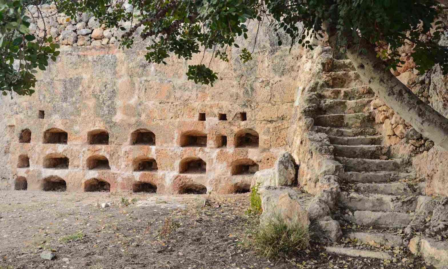
Xemxija Heritage Trail
Being in Malta you cannot fail to discover the Xemxija Heritage Trail, also known as the Pilgrims' Route or the Old Roman Trail. This walk will certainly be a classic example of how in Malta you can discover new archaeological finds every few steps. There are many diverse archaeological sites covering an area of only half a square kilometer, from the Neolithic era over 5,500 years ago, through the Punic and Roman periods. This area is well-kept and organized into an interesting heritage trail, starting up the hill from Roman times, which crosses the ridge next to ancient cave dwellings, tombs and apiaries, heading towards Mellieha. The free map of the "Xemxija Heritage Trail" available at the Bugibba tourist information point or in the local municipality of St Paul's Bay contains at least twenty places of interest. All archaeological curiosities are within walking distance from each other, so the trip takes about 90 minutes.
Marsascala to Marsaxlokk Bay
This is a moderately difficult rural trek that should take somewhere in the region of four hours to complete. Taking in the beautiful and varied landscapes that Malta has to offer the walk from Marsascala to Marsaxlokk Bay takes you between two harbours on the east coast of the Island and this is great for its breath taking scenery. If you start at the old Maltese fishing town of Marsascala and head towards Marsaxlokk you will pass through many places inaccessible by car, including some bays you can only visit by boat and some troglodyte dwellings that are still used. This walk lets you really get off the beaten track.
Dingli Cliffs
To truly be at one with nature, a hike along the Dingli Cliffs on the west side of the island is pretty hard to beat. Particularly from October to May, the surroundings are lush green with wildflowers in abundance along the route. In the past helping to protect Malta from invaders, these natural cliffs reach up to a highest point of just over 250 metres. At one of the highest points stands St Mary Magdalene chapel, dating back to the 17th century. The chapel is at the cliffs’ edge and stands alone, making it difficult to imagine how pilgrims managed to reach it. Views also offer that of the islet of Filfla. Although originally used as target practice by the forces, this minute place is now protected. Awash with wildlife, this limestone place measures a mere six hectares yet is unmissable from the Dingli Cliffs. Fifla even has its own wall lizard endemic to it. Despite its remoteness, the cliffs boast a restaurant for well-earned refreshments. The starting point is the small and quiet village Dingli and the finally you can reach the green woodland area of Buskett gardens and the Palace.
Marfa Ridge Country Walk
A walk along the rural ridge of Marfa Ridge leads to different places and reveals arable fields, forest areas, magnificent bays and cliffs. The walk begins in the northern part of Malta at the largest sandy beach on the islands, Mellieha Bay or Ghadira Bay. The trip can be started at Mellieha bus station and go to the gate, which is the entrance to the Ghadira Nature Reserve. Further towards Torri L-Ahmar, the Red Tower, we reach the top of Marfa Ridge. Walking towards the end of Marfa Ridge, you'll find a small chapel called the lonely chapel of the Immaculate Conception, built in the 19th century and completely rebuilt in the 1960s. After visiting the chapel, you can enjoy a magnificent view of the sea from the cliff edge before going further through arable fields, forest areas and high cliffs. Continuing the walk along the ridge of Marfa Ridge, we will get to It-Torri L-Abjad, the White Tower, and from there the trail turns up and leads to the picturesque Paradise Bay beach. After leaving Paradise Bay we go down to a dirt path that leads to areas with breathtaking views of the sea and small paths curving towards the terrace fields hanging on the cliff side, so not one may feel like on the Amalfi Coast. A little further you can explore the beautiful Maltese fauma, and a further walk will lead the Red Tower and the nature reserve of Ghadira. The walk on the Marfa ridge takes about 4.5 hours and is 11 km long.
Bahrija Country Walk
Trekking can be started from the west side of Rabat, the trail leads us through a rich and peaceful area, through valleys surrounded by green hills and coastal cliffs with magnificent sea views beyond the island of Filfla. We will start trekking in the small town of Bahrija, which has a lot to offer to history lovers, including a Bronze Age village and a small 17th-century church on a cliff overlooking the valley. The valley on the west from Bahrja is always green because of the water running all year around, including the hot and dry summer months. The walk is about 13 km long, and it will take 4 hours to complete it.
Dwejra/Victoria Lines Country Walk
This 10-kilometer trail will lead from Mgarr to Mosta. For about four hours we will be able to look at the history of Malta and its rich surroundings. First, passing through the small village of Bingemma, you can admire the small chapel, which was built by the Xara family in 1685 at the top of the cliff, which offers an amazing view of the Mgarr. From here you can walk to one of the best saved military forts from the times of the British Empire – Fort Bingemma and soon after to have a walk of the most intriguing part of the Victoria Line - The Bingemma Gap defensive bridge This part of the wall which today the locals call “ The Great Maltese Wall “. Later, the route leads along the Victoria lines, as well as preserved nineteenth-century fortification lines stretching 12 km above Malta, after which it ends in Mosta in the magnificent Mosta Dome.